Below is the 3 years in Review video I shot and compiled of most of the Johnson Avenue Surfers.
Don Wagoner is at the 2:25 mark if you want to jump right to it. It is a 7 or 8 shot sequence of still photos followed by a small small hand cam shot of his granddaughter Kamryn saying “Washule” (whatever the spelling is in karate kid 🙂 )
Rest in Peace brother Don <><
PS – We may have a paddle out for Don on Wednesday or Thursday this week. If Wednesday continues to show an epic chest high and glassy day, it may be appropriate to have that paddle out around 11 or noon at the end of Johnson Avenue. ALL WHO KNEW DON ARE INVITED!
If your phone loads too slow from the embeded video above, just click this YouTube link below.
Okay, I stopped surfing for 5 months, but Rip Van Winkle is alive again…
Here’s the challenge, Monday 04-24-17, we have a nice ground swell in the 2-3 foot range at 12-13 seconds, which could produce some head high faces on the biggest sets. But, we do have high tide at 6:40 AM, for Satellite Beach, we also have a front coming in from the Gulf it appears that will be sending powerful off shore winds cranking over the 10-15 mph range by perhaps as early as 10 or 11 AM Monday morning,and then increasing throughout the day.
It may be fun all day, but along with powerful west winds, there is also a 50% call for Scattered Thundershowers at 10 AM.
So, get out early, and find the best high tide break, and hopefully we’ll get 2 hours of really fun chest high surf 😉
I just love this feeling of making it, just barely over the top, compliments of magicseaweed.com, the article if you haven’t read it, about Grant Twiggy Baker is here:
I meant to post yesterday. For 3 days now, Fridayhas looked like Shoulder high an glassy , or chest to head, from the Pier working South.
Winds should be WNW at daybreak, in the 8 -12 mph range, and then slow down to maybe 9 or 10, and out of the NW by 9 or 10 am.
Low tide is 6: 30 AM in Satellite Beach, so dawn patrol is looking great. Brisk offshore winds should start around 2 in the morning, so it ought to be glassy at daybreak with no morning sickness I hope. The photo below should be about what we see !
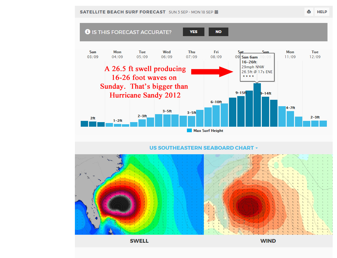
Hurricane Matthew appears to be moving further West, and looks to be making a direct impact on Cocoa Beach (possibly not, but I am not betting on it) , with at least Hurricane force winds and massive storm surge.
I hope that I am totally wrong. I have been tracking the storm details, at http://wunderground.com and it looks like it may be the first Category 5 storm in years near here.
Make adequate preparations my Surfer friends, and of course, God Bless 🙂
Will we have local wind, or secondary swell disturbance? Or will Tropical Storm Karl bring us the goods without Lisa’s throwing a tantrum?
The map below, compliments of awesome Wunderground.com weather, shows us that Karl about 1500 miles offshore, almost hurricane status, and Lisa, another 1500 miles out from Karl, should not interfere, and may even be slightly strengthening the gift from Karl.
The swell actually hit the 20 mile buoy last night around 10-11 PM (Wed night), along with the Fernandina Beach buoy and the Ft. Pierce Buoy all around the same time, which is actually rare.
Don’t expect any glass this afternoon, after this morning’s glass, but Friday morning, it could be blowing SW by 4 or 5 am, and turning NW by 10 or so, and onshore probably by noon, and maybe enough to prevent morning sickness and glass by daybreak. The winds are expected to be in the 4-7 mph range which is awesome. The tide is finally with us !!!! Size at daybreak, should be waist to chest high, from the Pier south, and by 9 or 10, we may see some shoulder high waves, at least on the bigger sets. Minus the wetsuit, surf could look like the video below on Friday.
Saturday, should be chest to head high, with maybe only a few hours mirror glass up North , NNW winds, and semi-glass in south CCB and maybe Satellite. Still light, so it may not throw much texture down South even though it’s expected to be NNW (which is almost onshore in Satellite Beach).
Sunday could be more of the same as Saturday. The period drops to 10 seconds from 11 or 12, which could make it better, worse, or the same, who knows ? 🙂
Update at 8:30 PM Thursday. The swell finally hit 3.3 feet at 12 seconds at 120 buoy, and winds were NNE to N , unlike the 7 mph west winds that were at the 20 mile up until 1:30, so that may have held the swell back.
NOTE: For Friday, The winds have switched to a NW to NNW direction for our offshore winds (they were going to be SW to West), so , only expect NW winds (which are still okay for Satellite, but if they go NNW, then 4rth St North is better, but anywhere North of Minuteman Cswy for NNW winds. So down south may still be best if it’s NW, and up until 9 am.probably)
End 8:30 PM Update
Today, TS Julia who literally formed over our heads the last couple days (rare for 20-30 years) and TS Ian way out in North Atlantic, bring us some nice waist to maybe chest by 10 am or if slow to arrive, by noon in Satellite Beach with glass until maybe 1 pm. The 20 mile buoy had 11 & 14 second reading back to back at 8-9 am this morning, which means, 2 hours from then or so it hits our beaches. Thus the 11 or 12 Pm prediction to hit the beaches with power and some nice size 🙂
Friday should be chest to head high with offshore winds till maybe noon.
Saturday should be waist to chest and offshore down south (and maybe up North offshore till 8 or 9am or so if it is truly SW winds). Offshore down south in Satellite till maybe 9 or 10 am.
Sunday maybe some waist high leftovers with more glass than Saturday.
Was the drive down to Spanish House worth it on Wednesday? Maybe. The swell was still iffy, but I heard Tuesday it was pretty excellent.
We made a treck down South and ended up at Satellite Beach. Got a few. A few in the water is better than a day in the office, right?
🙂
The video below earns it name damn well. MIND-BLOWING DROP-INS, BARRELS, WIPE-OUTS… and just plain phenomenal footage of the January 21st & 22nd JAWS swell of this year. (2016)