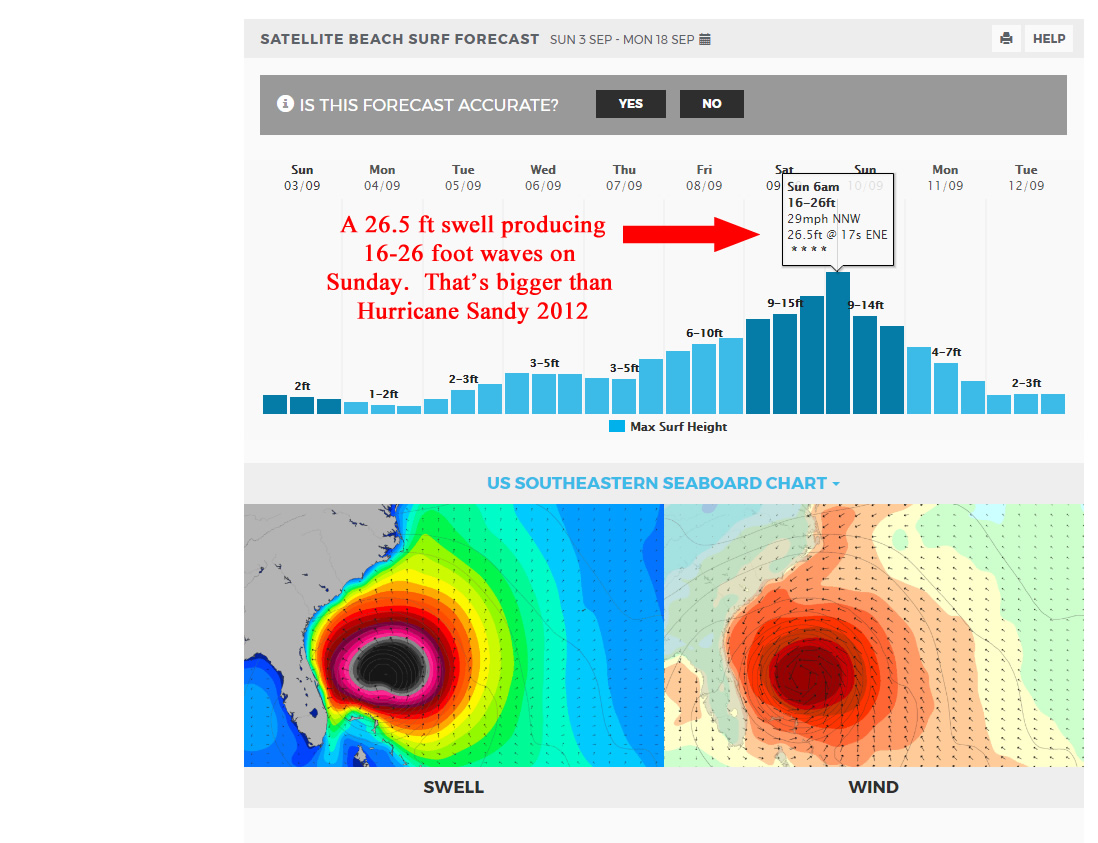
HURRICANE IRMA Last Updated: 9/3/2017, 5:00:00 AM (Eastern Daylight Time)

Okay, I stopped surfing for 5 months, but Rip Van Winkle is alive again…
Here’s the challenge, Monday 04-24-17, we have a nice ground swell in the 2-3 foot range at 12-13 seconds, which could produce some head high faces on the biggest sets. But, we do have high tide at 6:40 AM, for Satellite Beach, we also have a front coming in from the Gulf it appears that will be sending powerful off shore winds cranking over the 10-15 mph range by perhaps as early as 10 or 11 AM Monday morning, and then increasing throughout the day.
It may be fun all day, but along with powerful west winds, there is also a 50% call for Scattered Thundershowers at 10 AM.
So, get out early, and find the best high tide break, and hopefully we’ll get 2 hours of really fun chest high surf 😉
I just love this feeling of making it, just barely over the top, compliments of magicseaweed.com, the article if you haven’t read it, about Grant Twiggy Baker is here:

Oldwaverider
My bad !
I meant to post yesterday. For 3 days now, Friday has looked like Shoulder high an glassy , or chest to head, from the Pier working South.
Winds should be WNW at daybreak, in the 8 -12 mph range, and then slow down to maybe 9 or 10, and out of the NW by 9 or 10 am.
Low tide is 6: 30 AM in Satellite Beach, so dawn patrol is looking great. Brisk offshore winds should start around 2 in the morning, so it ought to be glassy at daybreak with no morning sickness I hope. The photo below should be about what we see !

Have Fun ! Be safe !
Oldwaverider
Will we have local wind, or secondary swell disturbance? Or will Tropical Storm Karl bring us the goods without Lisa’s throwing a tantrum?
The map below, compliments of awesome Wunderground.com weather, shows us that Karl about 1500 miles offshore, almost hurricane status, and Lisa, another 1500 miles out from Karl, should not interfere, and may even be slightly strengthening the gift from Karl.
 The swell actually hit the 20 mile buoy last night around 10-11 PM (Wed night), along with the Fernandina Beach buoy and the Ft. Pierce Buoy all around the same time, which is actually rare.
Don’t expect any glass this afternoon, after this morning’s glass, but Friday morning, it could be blowing SW by 4 or 5 am, and turning NW by 10 or so, and onshore probably by noon, and maybe enough to prevent morning sickness and glass by daybreak. The winds are expected to be in the 4-7 mph range which is awesome. The tide is finally with us !!!! Size at daybreak, should be waist to chest high, from the Pier south, and by 9 or 10, we may see some shoulder high waves, at least on the bigger sets. Minus the wetsuit, surf could look like the video below on Friday.
Saturday, should be chest to head high, with maybe only a few hours mirror glass up North , NNW winds, and semi-glass in south CCB and maybe Satellite. Still light, so it may not throw much texture down South even though it’s expected to be NNW (which is almost onshore in Satellite Beach).
Sunday could be more of the same as Saturday. The period drops to 10 seconds from 11 or 12, which could make it better, worse, or the same, who knows ? 🙂
Yep, Tuesday is flip floppin, and may have an epic daybreak session, but keep your eyes for Wednesday.
I’ll update a lot more on Monday, but we do have 3 storms involved again, 91L is the one close to land and in North Florida land, while Gaston will begin it’s turn toward Europe on Wednesday. Hopefully storm 99L will fizzle out as it passes under or thru the Southern tip of our state.
The 120 buoy is down for now, so we won’t have that 8-10 hour window to let us know the swell is approaching. The 20 mile buoy no action, nor Ft. Pierce.
The models show 3-5 foot on Tuesday or Wednesday, but don’t let that keep your hopes down on size. As I shared the other day, Hurricane Leslie was 4 feet at 11 or 12 seconds and put up some spotty 11 foot faces in Satellite. So some 8 or 9 foot faces can probably be found, if not bigger.
More on Monday 🙂
 Could Gaston actually bring us Big Glassy Waves?
I believe so, and here’s why:
First, Fiona is gone, so that takes away more onshore winds from 3 storms back to back. Then, Storm 99TL, is expected to fizzle out, while Gaston intensifies. (I added this part around 3:15 PM Wednesday, and that is, that I shouldn’t say, Storm 99TL fizzles out, because it actually will be the reason why the offshore winds that I hope arrive on Wednesday & Thursday, that is why they are so strong and adding winds out of the South to the offshores coming from Gaston. With Fiona gone, that is why we can at least have some offshore winds. But if 99TL is 45 mph winds and grazing over the Caribbean, even though it doesn’t take a Northern climb, that is still enough to send a Southernly breeze up toward our coast. I sure hope it does fizzle out though, not only for our surf, but also, more important, so people don’t have harm or damage around Cuba, Haiti & the Bahamas)
Storm details say that Gaston turns hurricane on Saturday. But still not far enough North of us to have offshore winds by then. However, then an upper wind shear (a low I believe) will weaken Gaston a little, and then by day 5, Monday, it is expected to intensify up to perhaps 100 mph winds. That is probably why the Magicseaweed.com models show such good waves for Wednesday thru possibly Friday. This makes sense, because by Monday sometime, the storm is expected to head North as opposed to it’s current WNW bearing, and once it is a couple hundred miles North of us, wallah, those offshore winds.
 Keep in mind, that this storm is much further out than our normal hurricanes from Africa. This one will be about 2000 miles offshore. So that is why the models show a 3 or 3.5 foot swell at whatever, 13 to 15 seconds. But remember, Hurricane Leslie of 2012 was 4 feet at 12 seconds and gave us some 11 foot face waves in Satellite Beach 🙂
It’s still far out, but I think we will get 2 glassy days (Wed & Thurs perhaps next week), maybe the first a late afternoon glass, but nonetheless, 2 days of chest to 1 foot overhead, and glassy, at least down south. And the typical 20-40% smaller up North but still perhaps awesome.
Oldwaverider

Fiona, is she going to bring us any fun waves?
 Perhaps, we will feel some of the fetch by evening next Saturday the 27th. The models show some size overhead on Sunday the 28th, though with onshore winds still. Below I post the Wunderground Storm details, which if the former of the two predictions hold up as stated below in quotes, we could have some fun waves blown in by a tropical depression, with the winds turning offshore as it reaches 100 miles North of us. (as is always the case for the winds to turn offshore for a hurricane 🙂
With a little good fortune, perhaps sometime Monday the 29th we could have some nice waves!
Storm details from Wunderground.com : “A combination of a dry air mass, increasing vertical wind shear, and convergent upper-level flow should cause Fiona to weaken for the next 3-4 days. The intensity forecast follows the guidance consensus in calling for the cyclone to weaken to a depression by 48 hours, and then remain at about a 30 kt intensity through the rest of the forecast period. An alternative scenario is that the system weakens more than currently forecast and decays to a remnant low sometime before day 4. As noted in the previous discussion, the environmental conditions might get less hostile by day 5.”
 Is it worth getting up to meet the Morning Sun?
I think so. The scattered thunderstorms that were going to meet us at daybreak, appear to have post-poned until 10 or 11 am, well, at least in Satellite Beach 🙂
This looks almost to be a groundswell, and it stretches out a couple thousand miles, (no not of full period strength), but at least covers a couple thousand miles at least 🙂
Wednesday morning for 1, maybe 2 hours has a great chance of being rib to chest high, with bigger sets, and offshore SW winds in the 3-5 mph range… but maybe, and only until 9 a.m. High tide at 8:45 am, so that’s another reason to do dawn patrol.
Enjoy it boardmen, boardwomen !
🙂
Oldwaverider

